SLAM and 3D LiDAR mapping for cities and infrastructure.
Dashify surveys streets and urban corridors, reconstructs the environment as a point cloud, and delivers poles, arms, trees, sidewalks, facades and signs as measurable georeferenced data.
Vehicle and handheld surveys, 3D processing, classification and GIS delivery
360°capture around the mobile system
3Dgeometry for measurement, classification and inventory
SLAMlocalization and mapping performed together
3D mapping technology
SLAM locates the system while LiDAR measures the world around it.
The result is more than a sequence of photographs. It is a continuous three-dimensional representation of the surveyed corridor, linked to a trajectory and prepared for control, classification, measurement and geographic-system integration.
SLAM
Simultaneous localization and mapping
SLAM estimates equipment motion while registering new observations into the same map. It reduces exclusive reliance on GNSS and helps preserve continuity under trees, near buildings, in passages or where satellite signals degrade.
LiDAR
Laser pulse measurement
LiDAR measures the return time of light pulses to calculate distances. Millions of readings form a 3D point cloud that represents surfaces, heights, volumes and clearances.
FUSÃO
Sensors working together
LiDAR, an inertial unit, GNSS and panoramic imagery can be combined to stabilize the trajectory, add visual context, control quality and place the survey in the project's coordinate system.
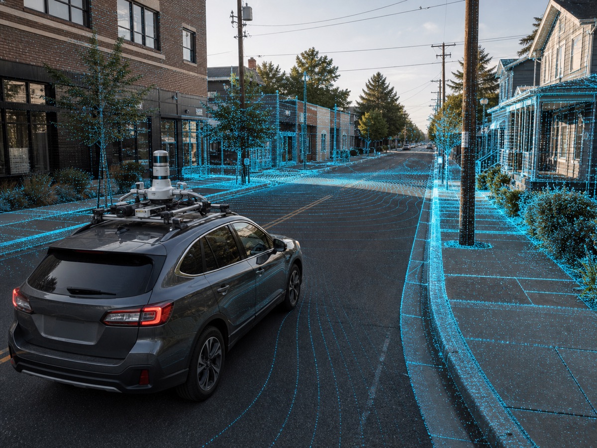
Vehicle mobile mapping
More field coverage without reducing the urban corridor to isolated points.
The mobile system records complete geometry as the vehicle travels. Teams can review, measure and classify in the office, reducing repeated traffic exposure and making inventory updates more consistent.
Continuous acquisition
Streets and avenues are captured as connected corridors instead of requiring manual measurement of every asset during the initial pass.
Complete context
Poles, trees, facades, sidewalks, signs and pavement remain spatially related in one three-dimensional scene.
Auditable measurements
The point cloud supports review of height, diameter, tilt, distance and interference using a registered and controlled data source.
Comparable updates
New campaigns can repeat corridors to identify changes, removed assets, vegetation growth or road modifications.
Official video
Dashify SLAM
Mobile SLAM and 3D LiDAR mapping for streets, avenues, poles, luminaire arms, urban trees, facades and georeferenced asset inventories.
Six survey scenarios
Dashify combines vehicle and handheld capture across different environments.
Our operation combines vehicle speed, 360-degree coverage and handheld mobility to document extensive corridors and areas a car cannot enter.
Vehicle mobile mapping
Our team uses an integrated vehicle system to survey large infrastructure areas with a continuous trajectory and synchronized imagery and point clouds.
LiDAR + SLAM + GNSS + 360 imagery
Streets and neighborhoods
The survey documents carriageways, gutters, sidewalks, access points, facades, visible utilities and street furniture in residential and commercial corridors.
Road geometry, sidewalks and urban frontages
Avenues and main corridors
The capture covers multiple lanes, medians, intersections, signals, shelters, drainage and lighting within one three-dimensional reference.
Wide corridors and connected assets
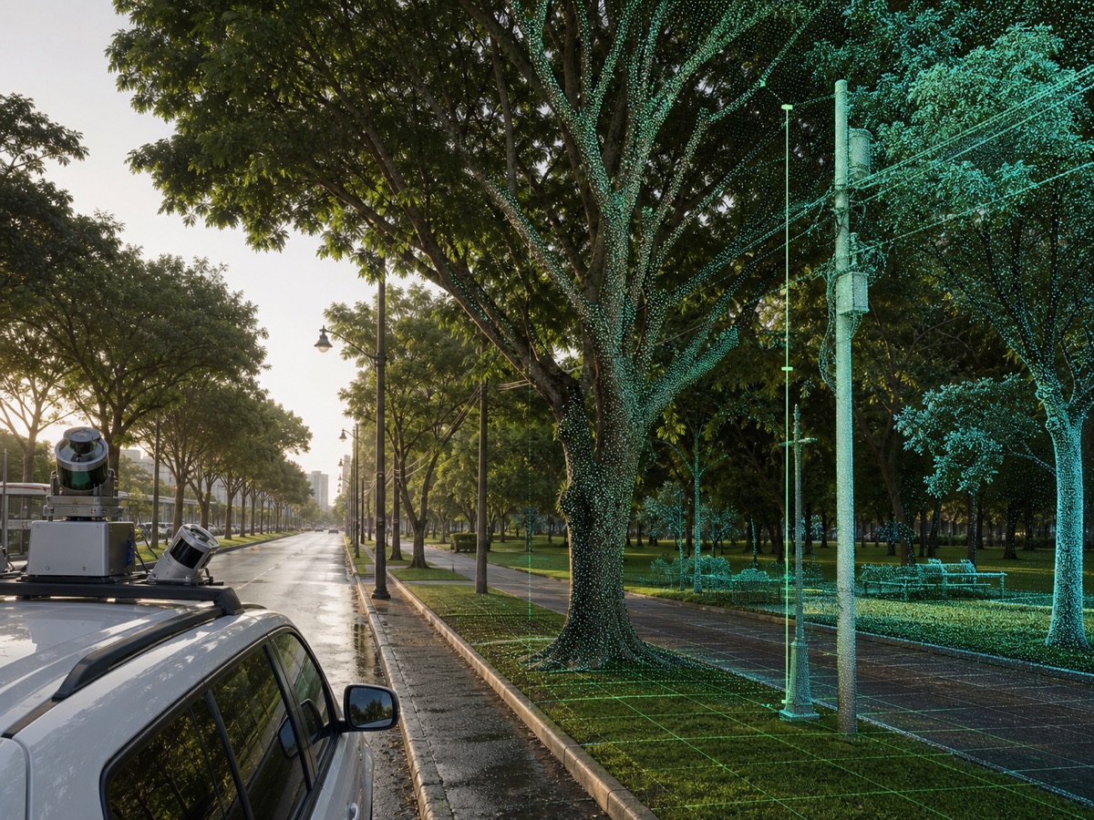
Urban forestry
Processing records location, height, apparent diameter, canopy volume and proximity among trees, poles, facades, circulation routes and overhead networks.
Tree inventory and interference analysis
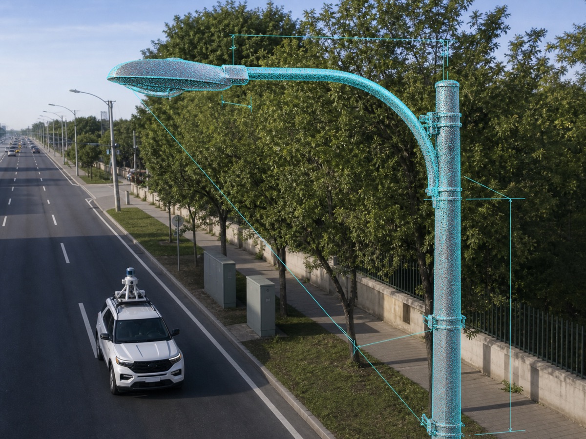
Poles, arms and luminaires
Technical extraction delivers position, height, tilt, arm length and orientation, plus distances among assets, canopy, roadway and buildings.
Public lighting and vertical infrastructure
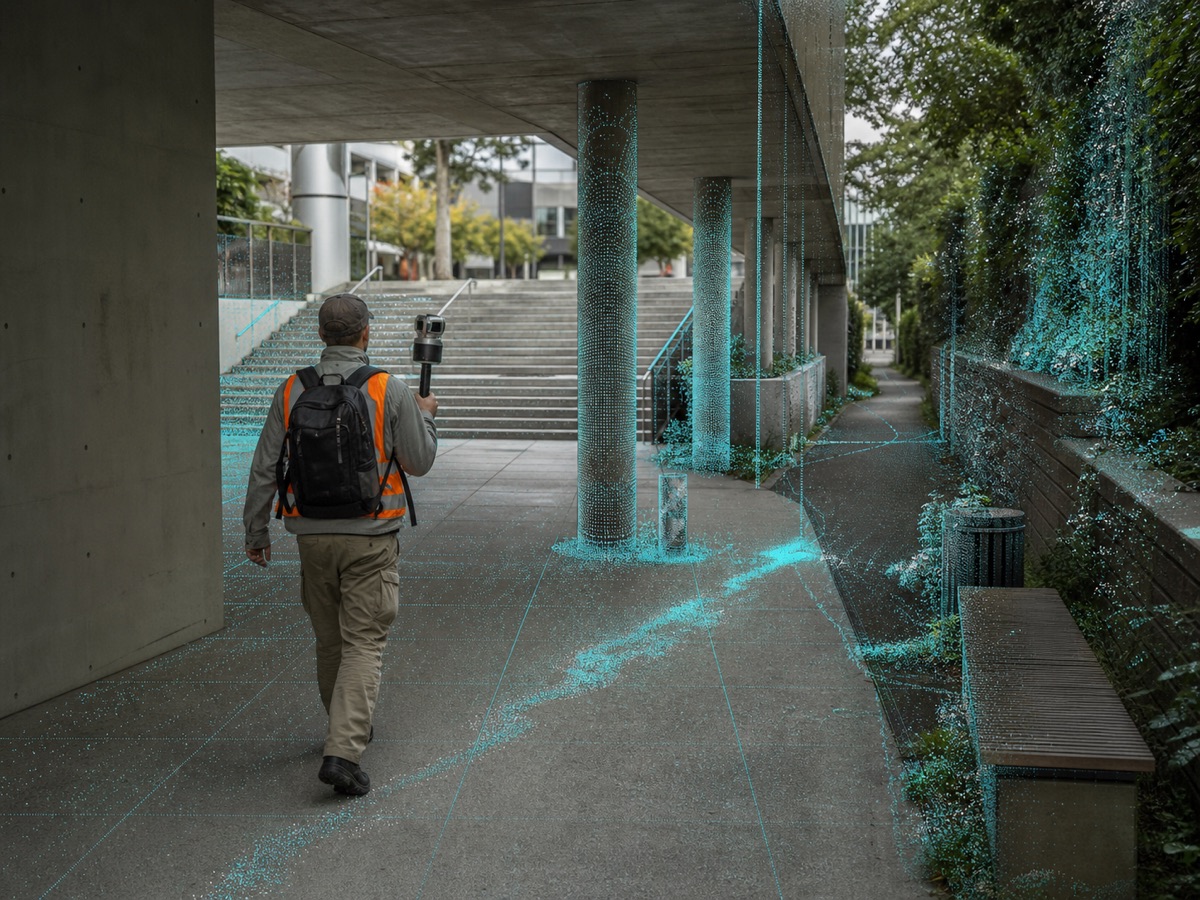
Handheld SLAM and restricted areas
Our team completes the survey in plazas, passages, stairs, interiors, alleys and covered areas using a handheld scanner or mapping backpack.
Continuity where vehicles cannot access
X · Y · Z
Useful geometry for engineering and inventories
Dimensions and spatial relationships calculated without revisiting every asset.
The point cloud preserves the scene's three-dimensional shape. After processing and control, it can support measurements, records, designs, inspections and maintenance decisions.
Poles and columns
Position, height, verticality, diameter and clearances.
Arms and luminaires
Length, projection, elevation and spatial orientation.
Trees and canopies
Trunk, height, canopy extent and interference.
Roadways and sidewalks
Edges, widths, level changes, ramps and corridor sections.
Signs and traffic signals
Location, height, orientation and relationship to the road.
Facades and envelopes
Planes, distances, apparent volumes and urban envelope.
Dashify defines and documents tolerances, calibration, acquisition conditions, control points and validation methods according to each project's required accuracy.
Controlled technical workflow
From the field route to an inventory ready for decisions.
Dashify conducts planning, acquisition, processing and control under one quality framework, with a methodology tied to the contracted products.
01
Project scope and classes
Our team defines corridors, assets, attributes, coordinate systems, tolerances and delivery formats.
02
Calibration and control
Sensors, synchronization, control points, control trajectories and acceptance criteria are verified before and during execution.
03
Vehicle and handheld capture
Routes are surveyed with controlled coverage, including handheld capture in areas hidden from or inaccessible to the vehicle.
04
Trajectory and point-cloud adjustment
Observations are combined to correct drift, register passes, georeference data and remove survey noise.
05
Asset classification and extraction
Ground, vegetation, buildings and objects are classified to generate records and measurements according to the contracted scope.
06
Validation and publishing
Delivery includes sample control, quality documentation, 3D data, GIS layers, inventories and reports.
Data products
Deliverables prepared for engineering, GIS and asset operations.
Delivery is structured around the contracted application, combining point clouds, inventories, models and reports with formats and levels of detail defined in scope.
3D point cloud
Registered, georeferenced and organized data in formats such as LAS, LAZ or E57 according to project requirements.
GIS layers
Points, lines and polygons with attributes in GeoPackage, SHP, GeoJSON or an equivalent integration.
Asset inventory
Records for poles, luminaires, trees, signs, signals and other elements with position and attributes.
3D model and corridor
Sections, profiles, meshes or simplified models for analysis, design, visualization and digital twins.
Quality report
Methodology, equipment, controls, coverage, limitations, samples and consistency indicators.
Temporal comparison
Repeated campaigns supporting change detection, vegetation growth analysis and record updates.
Technical execution and control
Dashify conducts every survey with measurable acceptance criteria.
Dashify's team plans routes, defines classes and tolerances, performs vehicle and handheld capture, controls coverage and accuracy, processes point clouds, and delivers GIS-ready integrations. Clients receive a complete, documented and scalable service.
Questions about SLAM and LiDAR
Documented technical criteria for every mobile 3D survey.
Clear information about the technology, positioning, accuracy, handheld capture and data products delivered by Dashify.
SLAM means simultaneous localization and mapping. The algorithm estimates the sensor trajectory while building and registering a map of the observed environment. It can maintain continuity when GNSS varies, provided there is sufficient geometry and the survey follows an appropriate methodology.
LiDAR emits light pulses and measures their return time to calculate distance. Each return becomes a 3D point; millions of them form a cloud representing surfaces, objects, vegetation, roads and buildings.
Not necessarily. In professional mobile mapping, SLAM, GNSS and an inertial unit usually complement one another. GNSS provides global positioning, the inertial unit records motion, and SLAM uses observed geometry to preserve and refine the trajectory.
There is no single number valid for every project. Accuracy depends on the sensor, calibration, speed, distance to objects, geometry, GNSS coverage, control points and processing. Dashify's technical proposal documents tolerance, verification method and final product.
Handheld scanning is suitable for plazas, alleys, stairs, covered passages, interiors, pedestrian areas and zones hidden from the vehicle system. Both methods can be registered in the same reference according to the survey plan.
Depending on scope, delivery can include LAS, LAZ or E57 point clouds, GIS layers, asset inventories, panoramic imagery, profiles, sections, meshes, 3D models and a quality-control report.
3D surveying driven by its use
Complete 3D mapping execution, from planning through delivery.
Dashify handles vehicle and handheld surveying, processing, quality control and data delivery for urban inventories, engineering, forestry, public lighting, mobility and digital twins.